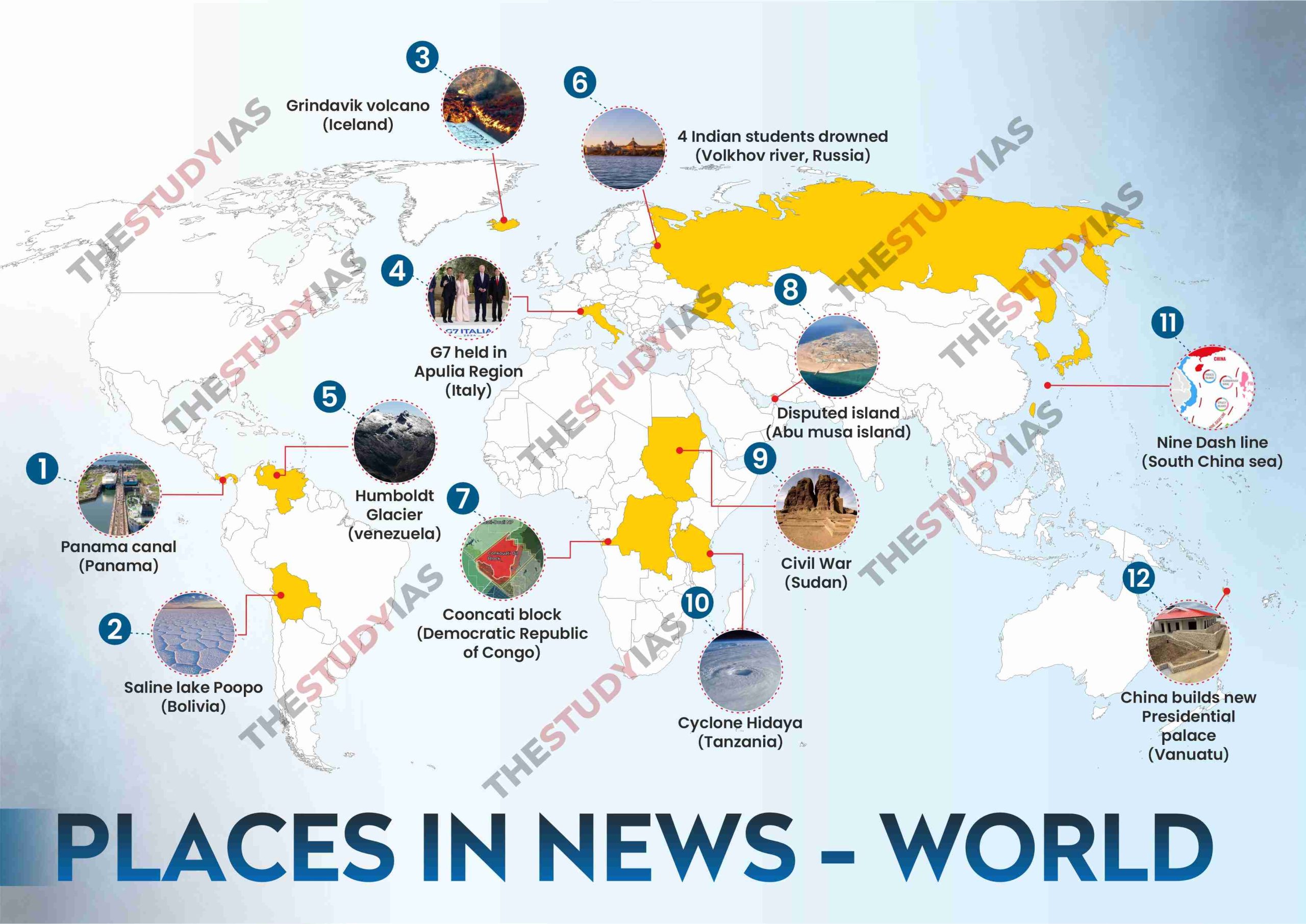
Places in News.
1. Places in News: Panama Canal
Context :
Climate change led to drought in Panama.
The Panama Canal is an artificial 82-kilometre waterway in Panama.
runs through a narrow strip of land called the Isthmus of Panama
It connects the Atlantic Ocean with the Pacific Ocean.
It is bordered on the land by two countries: Costa Rica and Colombia.
3 Lakes Through which Panama Canal passes:
Gatun Lake
Alajuela Lake
Miraflores Lake.
2. Places in News: Bolivia
Context:
Bolivia has experienced significant political instability, highlighted by recent coup attempts, which showcase the fragility of its democracy.
More on News:
The military’s intervention has drawn international condemnation, emphasising concerns about the legality of these actions and the challenges faced by fledgling democracies.
Historical issues and social divisions contribute to Bolivia’s susceptibility to coups.
About Bolivia:
Location & Geography:
Landlocked country in western-central South America.
Official Name: Plurinational State of Bolivia.
Situated in the Andes Mountains, with a highland plateau and lowland plains in the Amazon basin.
Borders: Argentina, Brazil, Chile, Paraguay, and Peru.
Capital Cities:
Constitutional Capital: Sucre.
Executive Capital: La Paz (seat of government).
Largest City: Santa Cruz de la Sierra (industrial hub).
Natural Features:
Shares Lago Titicaca with Peru, the world’s highest navigable lake (12,500 feet above sea level).
Highest Peaks: Sajama.
Largest Inland Lake: Salty Lake Poopó.
Major Rivers: Madeira, Mamoré, Beni, Pilcomayo, and Desaguadero Rivers.
Economy:
Mixed economic system with centralised planning, and regulation.
Major Producer of natural gas.
Rich in minerals, with significant exports of zinc, silver, tin, and lead.
Vegetation:
Altiplano: Dry, saline areas with grasses and shrubs.
Yungas: Mountain rainforest with diverse hardwoods and medicinal plants.
Oriente: Varied vegetation, from Amazonian rainforest in the north to scrub in the Chaco.
3. Places in News: Iceland
Context:
A volcano erupted in Grindavik, Iceland resulting in a series of earthquakes.
About Iceland:
Location: North Atlantic Ocean, between North America and Europe.
Tectonic Setting: Situated on the Mid-Atlantic Ridge, on an active geologaic border between the North American and European plates, contributing to high volcanic activity
Borders:
North: Greenland Sea.
East: Norwegian Sea.
South and West: Atlantic Ocean.
Northwest: Denmark Strait (separates Iceland from Greenland by about 200 miles or 320 km).
Neighbouring Countries: Greenland, Faroe Islands, Scotland, Norway
It is the second-largest island in Europe after Great Britain and the 18th largest island globally.
Natural Landscapes:
Glaciers (Including Vatnajokull, Europe’s largest glacier), Hot Geysers, mountains, volcanoes and lava fields.
Climate: Mild climate influenced by the Gulf Stream.
Arctic Circle Proximity: Northernmost peninsula nearly touches the Arctic Circle
Due to its diverse landscape of both volcanic activity and glaciers, Iceland is often referred to as the “Land of Fire and Ice”.
4. Places in News: Italy
Context:
On June 14, 2024, the Indian Prime Minister attended the G7 summit in Italy’s Apulia region and held bilateral meetings with world leaders such as the British Prime Minister, French President, and Pope Francis.
More on News:
At the G-7 Summit, the Prime Minister called for ending technology monopolies and promoting creativity for an inclusive society.
Invited leaders from 11 developing countries in Africa, South America, and the Indo-Pacific region to attend the G7 Summit, alongside India.
Official Name: Italian Republic
Capital: Rome
Official Language: Italian
Currency: Euro (€)
Location: Southern Europe, bordered by France, Switzerland, Austria, Slovenia, and the Mediterranean Sea.
Geography: Shaped like a boot, Islands like Sicily and Sardinia are also part of the country.
Major Mountain Ranges: Alps, Apennines.
Major Rivers: Po, Adige, Arno, Tiber.
Major Cities: Rome, Milan, Naples, Turin, Venice, Florence.
Historical and Cultural Significance
Birthplace of the Roman Empire, a major center of ancient civilisation.
Renaissance: It was the cradle of the Renaissance, with cities such as Florence being cultural and artistic centres.
Climate: Temperate Mediterranean.
Economy: Developed, High-Income:
Industries: Known for automotive (Fiat, Ferrari), fashion (Gucci, Prada), and food (olive oil, wine, cheese).
Tourism: One of the world’s top tourist destinations, famous for its art, history, cuisine, and landscapes.
Culture and Society
Art and Architecture: Home to artists like Leonardo da Vinci, Michelangelo, and architects like Palladio.
Cuisine: Renowned worldwide, featuring dishes like pasta, pizza, risotto, and regional specialties.
Fashion: Milan is one of the world’s fashion capitals, hosting major events like Milan Fashion Week.
Key Landmarks
Colosseum: Ancient amphitheater in Rome.
Leaning Tower of Pisa: Iconic tilted bell tower.
Vatican City: Independent city-state, headquarters of the Roman Catholic Church.
Sports: Football (soccer) is highly popular but other sports include basketball, volleyball, tennis, and cycling.
Italy has won the FIFA World Cup four times.
Language: UNESCO reports 30 dialects and minority languages spoken in Italy, ranging from Venetian in the northeast to Tuscan, Ligurian, and Sicilian in the center.
5. Places in News: Venezuela
Context :
Venezuela’s last standing glacier Humboldt shrinks to an ice field.
More on News :
The International Cryosphere Climate Initiative (ICCI), a scientific advocacy organisation, said that Venezuela’s last standing glacier Humboldt, or La Corona, in the Andes — “too small to be classed as a glacier”. Hence the glacier has been reclassified as an ice field.
The country had been home to 6 glaciers in the Sierra Nevada de Mérida mountain range.
By 2011, five of the glaciers had vanished, leaving only the Humboldt glacier remaining.
Indonesia, Mexico, and Slovenia are next in line to become glacier-free as the world is experiencing record-breaking temperatures over the past couple of years.
Capital : Caracas.
Bordering Countries : Brazil, Colombia and Guyana.
Official language : Spanish
Country’s natural resources : Natural gas, iron ore, gold, bauxite, diamonds and Petrol.
Part of the Organization of the Petroleum Exporting Countries(OPEC).
Venezuela holds the largest oil reserves in the world i.e. around 18.2% of the world’s total oil reserves(OPEC).
Geographical regions within the country:
Venezuelan Highlands are theare : Are the mountains that border the Caribbean Sea. Lies in the northeasternmost extension of the Andes Mountain chain.
Maracaibo lowlands : North-western part of the country. The Maracaibo lowlands are surrounded by mountains on three sides and are quite flat. Lake Maracaibo dominates the area which is known for its oil fields.
Orinoco plains/ Los Llanos : Lowlands and Orinoco river flows through this.
Guiana region : Lies in the south and consists of plateaus, making up over half of the country. Angel Falls, the highest waterfall in the world, lies in this region.
Major rivers : Rio Negro, Orinoco River.
Agatti Island in Lakshadweep
Agatti Island is situated approximately 459 km (248 nautical miles) from Kochi and is located to the west of Kavaratti Island.
It boasts one of the most stunning lagoons in the region.
Agatti’s lagoons are rich in coral growths and multicoloured coral fishes.
Agatti is the virtual gateway to the Lakshadweep islands.
6. Places in News: Volkhov River
Context:
Four Indian students studying in Veliky Novgorod, Russia, drowned in the Volkhov river.
About Volkhov River:
Location: Volkhov River is situated in northwestern Russia.
Origin: It is the major outlet for Lake Ilmen.
It is the second largest tributary of Lake Ladoga.
It has several smaller rivers that flow into it.
These include the Vishera, which joins the Maly Volkhovets armlet on the right side.
The Kerest, Oskuya, Pchyovzha, Tigoda, Chyornaya, Vloya, and Olomna, which flow in from different directions.
Length: The river spans 139 miles (224 km).
Drainage Basin: Drains a basin of 31,000 square miles (80,200 square km).
Freezing: The river is frozen from mid-November to mid-April.
Hydroelectric Station: At the town of Volkhov, the first hydroelectric station in the Soviet Union was built in 1926.
Historical Significance: In early times, it was part of the important Baltic Sea–Black Sea trade route.
Lake Ladoga:
Location: It is situated in northwestern Russia, approximately 25 miles (40 km) east of St. Petersburg.
Size: It is the largest lake in Europe.
Formation: The depression of the lake was formed by the actions of glaciers.
Major Tributaries: Include the Volkhov, the Svir, and the Vuoksa rivers.
7. Places in News: Democratic Republic of the Congo
Context:
Local and international conservation groups are voicing strong opposition to the issuance of an oil and gas exploration permit for the Conkouati block in the Republic of Congo.
The permit was granted to China Oil Natural Gas Overseas Holding United, a Chinese fossil fuel company.
Conkouati-Douli National Park:
Location: In the southwest of the Republic of Congo, on the border with Gabon.
Geographical Features: Bordered by the Atlantic Ocean and intersected by a river.
Establishment: Originally a wildlife reserve (Conkouati Wildlife Reserve) established in 1980, upgraded to a national park in 1999.
Conservation Status: Recognised as a Ramsar Site and listed on the indicative list of UNESCO World Heritage sites.
Habitat: Includes unique coastal, marine, and forest habitats, forming a contiguous area with Gabon’s Mayumba National Park totalling 600,000 hectares.
Wildlife:
Forest – elephants, buffalo, leopards, chimpanzees (7% of global population), sitatungas.
Lagoon – hippos, manatees, nesting leatherback turtles.
Marine – dolphins, humpback whales (annual migration with breaching).
Chimpanzee Sanctuary: Hosts a chimpanzee sanctuary operated by the NGO HELP CONGO.
About Democratic Republic of the Congo:
Location: Central Africa, landlocked except for a small Atlantic coast.
Form of Government: Republic.
Size: Second-largest country in Africa (after Algeria).
Capital: Kinshasa (largest city in Central Africa).
Official Languages: French.
The country also recognises four national languages: Kikongo (Kituba), Lingala, Swahili, and Tshiluba.
Geography: The country borders 9 countries which include Angola, Burundi, Central African Republic, Republic of Congo, Rwanda, South Sudan, Zambia, Tanzania, and Uganda.
Major Mountain Ranges: Mount Stanley (highest mountain 5,109 meters), Mount Emin, Karisimbi, Mikeno etc.
Major Rivers: Congo River, Lomami River, Aruwimi River etc.
Climate: In the equatorial climate zone, located near the Equator, temperatures are high (annual average for Yangambi 24.6°C), humidity is high and rains fall throughout the year averaging between 1,600 mm and 2,000 mm annually.
Natural Resources: Incredibly rich in minerals (diamonds, cobalt, copper), vast forests, and high hydropower potential.
8. Places in News: Abu Musa Island
Context:
China reaffirmed its support for the United Arab Emirates in a rare public disagreement with Iran over disputed Gulf islands, marking a rare clash between Beijing and Tehran.
More on News:
China supports the UAE’s efforts to resolve the issue peacefully through bilateral negotiations in accordance with international law.
Iran seized control of the islands in 1971, just before the UAE became a country, and has administered them ever since.
Arab Gulf states and Russia have also expressed support for the UAE’s claim to the islands, calling for a peaceful solution to the dispute.
Key Highlights:
Disputed islands: Three islands—Greater Tunb, Lesser Tunb, and Abu Musa.
Iran and the UAE are in a territorial dispute over certain islands, with China maintaining its position despite Iran’s protests.
Strategic cooperation: China maintains strong ties with Iran despite ongoing tensions, which were addressed in a 2022 joint statement with Gulf Cooperation Council (GCC) countries.
Stability in the region: China’s steadfast stance underscores its commitment to regional stability, balancing its relations with both Iran and the UAE.
About Abu Musa Island:
Also known as “Gap-sabzu” meaning “the great green place”.
Situated close to the borders of Iran, the United Arab Emirates (UAE), and Oman.
An island in the eastern Persian Gulf, near the entrance to the Strait of Hormuz.
The highest point on the island is Mount Halva, which is 110 metres (360 ft) above sea level.
The island is administered by Iran as part of its Hormozgan Province.
9. Places in News : Sudan
Context:
The ongoing civil war in Sudan represents a big problem with how the country’s governing structure, along with power conflict between two military generals.
About Sudan:
Location: Sudan is a country situated in northern Africa.
Capital: Khartoum (Situated at the confluence of the White and Blue Niles rivers.
Borders: Sudan shares its borders with Egypt, Eritrea, Ethiopia, the Red Sea, South Sudan, Chad, the Central African Republic and Libya.
Resources and Power:
Oil: Sudan has oil reserves, first discovered in the southwestern part of the country in 1977.
Other Minerals: Sudan also has mineral deposits such as gold, uranium, chromite, gypsum, mica, marble, and iron ore.
However, not all of these resources are fully utilized.
Independence: Sudan gained independence from British rule in 1956.
10. Places in News: Tanzania
Context :
Cyclone ‘Hidaya’, a severe storm, is heading towards the Tanzanian coast from the Indian Ocean.
About Tanzania:
Lies in East Africa.
Home to Mount Kilimanjaro, Africa’s highest mountain.
Three of Africa’s great lakes are partly within Tanzania.
Lake Victoria- Africa’s largest lake.
Lake Tanganyika- Africa’s deepest lake.
Lake Malawi
Bordering countries: Burundi, Democratic Republic of the Congo, Kenya, Malawi, Mozambique, Rwanda, Uganda, Zambia.
Natural Resources: Iron ore, coal, diamonds, gemstones (including tanzanite, found only in Tanzania), gold, natural gas, nickel.
11. Places in News: South China Sea
Context:
Recently, China cautioned the United States against intervening in its maritime disputes with the Philippines, following a recent confrontation near a contested reef in the South China Sea.
About South China Sea
Location and Boundaries:
The South China Sea is an arm of the western Pacific Ocean bordering Southeast Asia.
It is bounded to the northeast by the Taiwan Strait (linking it to the East China Sea), to the east by Taiwan and the Philippines, to the southeast and south by Borneo, the southern edge of the Gulf of Thailand, and the east coast of the Malay Peninsula, and to the west and north by the Asian mainland.
Geographical Characteristics:
The eastern side of the basin features a sharp drop-off near the Philippine islands of Luzon and Palawan, forming the Palawan Trough.
The northwest side includes a broad, shallow shelf including the Gulf of Tonkin, Taiwan Strait, and large islands like Hainan and Taiwan.
To the south, the shelf narrows and connects with the Sunda Shelf, which spans between Borneo, Sumatra, and the Malay Peninsula. This shelf includes the southern South China Sea, Gulf of Thailand, and Java Sea.
Connections and Channels:
The Taiwan Strait (north).
The Luzon Strait (east) connects the South China Sea with the Pacific Ocean.
Shallow channels are located along the Philippine island chain and between Borneo and Sumatra.
The Strait of Malacca (west) is the main connection to the Indian Ocean.
Hydrology:
Major rivers flowing into the South China Sea include the Pearl River (Xi River), the Red River, and the Mekong River.
Territorial Claims:
China’s Nine-Dash Line: China’s claims overlap with the exclusive economic zones (EEZs) of Brunei, Indonesia, Malaysia, the Philippines, Taiwan, and Vietnam.
Paracel Islands: China controls the entire Paracel Islands, which are also claimed by Taiwan and Vietnam.
Spratly Islands: China, Taiwan, Vietnam, Malaysia, Brunei and the Philippines.
Scarborough Shoal: China and Taiwan claim Scarborough Shoal, while the Philippines claims it is within its EEZ.
Natuna Islands: Indonesia claims the waters around the Natuna Islands, which overlap with China’s nine-dash line claim.
12.Places in News: Vanuatu
Context:
China has constructed a new presidential palace in Vanuatu, a country in the Pacific.
About Vanuatu
Location: Southwestern Pacific Ocean
Capital: Port-Vila, located on Efate.
Neighbouring Countries: Lies to the east of Australia, northeast of New Caledonia, west of Fiji, and southeast of the Solomon Islands.
Geography: A chain of 13 principal and many smaller islands
The islands form an irregular Y shape, extending north-south for approximately 400 miles (650 km).
Seismic Activity: Frequent earthquakes indicating structural instability.
The terrain of Vanuatu is diverse and is famed for its gorgeous islands and active volcanoes.
Active Volcanoes: Sere’ama (Vanua Lava), Monaro (Aoba), Garet (Santa Maria), Benbow and Marum (Ambrym), Yasur (Tanna)
Wildlife: Approximately 10 types of bats are found here (with three species unique to Vanuatu) and home to the estuarine crocodile.
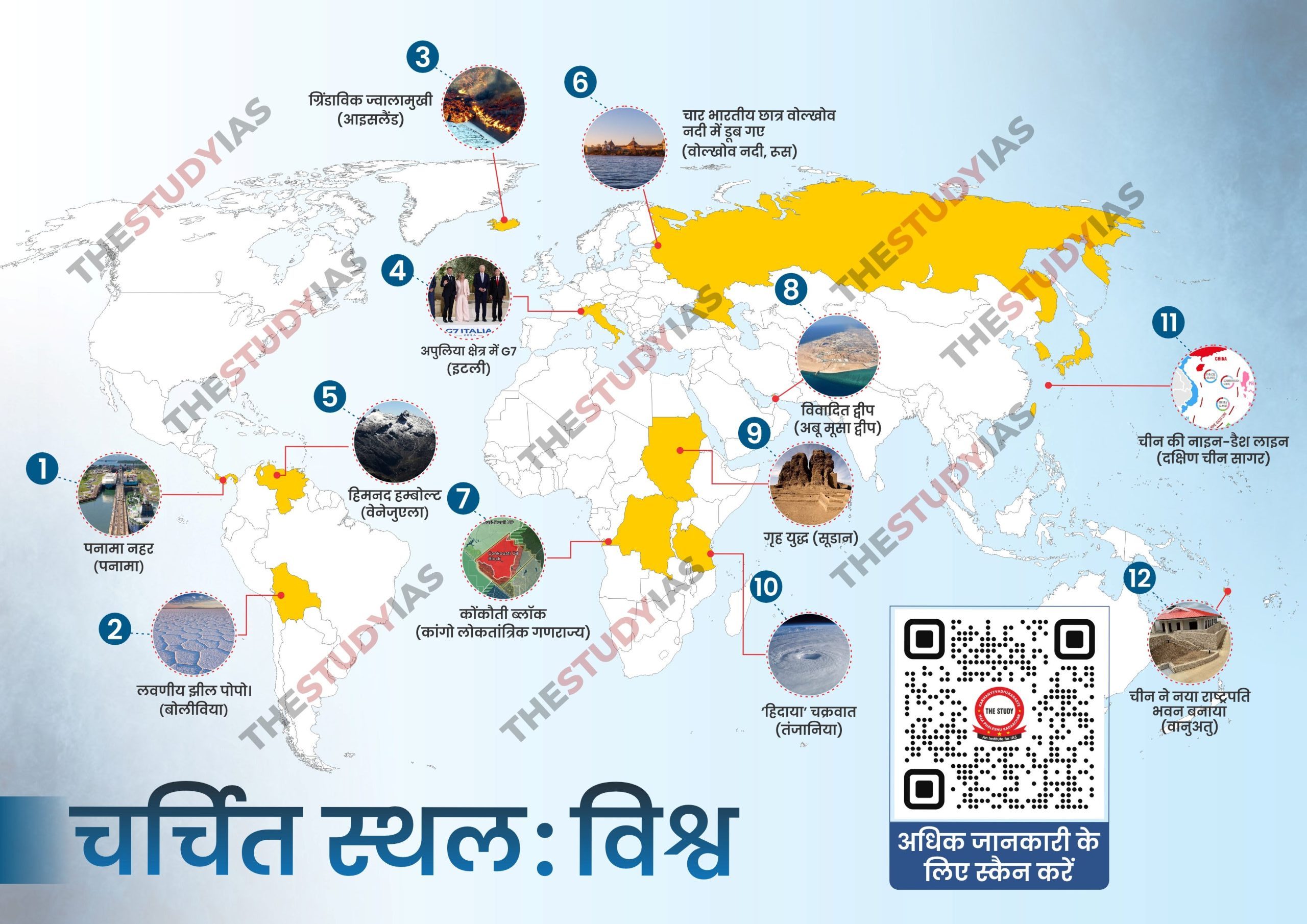
1.चर्चित स्थान: पनामा नहर
संदर्भ:
जलवायु परिवर्तन के कारण पनामा में सूखे की स्थिति।
पनामा नहर, पनामा में 82 किलोमीटर का एक कृत्रिम जलमार्ग है।
यह भूमि की एक संकीर्ण पट्टी से होकर गुजरती है जिसे पनामा का इस्तमुस कहा जाता है।
यह अटलांटिक महासागर को प्रशांत महासागर से जोड़ता है।
इसकी भूमि सीमा दो देशों से लगती है: कोस्टा रिका एवं कोलंबिया।
3 झीलें जिनसे होकर पनामा नहर गुजरती है:
गैटुन झील
अलाजुएला झील
मिराफ्लोरेस झील
2. चर्चित स्थान: बोलीविया
संदर्भ:
बोलिविया ने हाल के वर्षों में महत्वपूर्ण राजनीतिक अस्थिरता का अनुभव किया है, जिसे कुछ समय पूर्व हुए तख्तापलट के प्रयासों ने उजागर किया है, यह प्रयास इसके लोकतंत्र की नाजुकता को प्रदर्शित करता हैं।
चर्चा में क्यों?
अंतर्राष्ट्रीय स्तर पर इस सैन्य हस्तक्षेप की निंदा की गई है, तथा इन कार्रवाइयों की वैधता तथा नवोदित लोकतंत्रों के समक्ष आने वाली चुनौतियों के विषय में चिंता व्यक्त की गई है।
ऐतिहासिक मुद्दे और सामाजिक विभाजन बोलिविया को तख्तापलट के प्रति संवेदनशील बनाते हैं।
बोलीविया:
अवस्थिति एवं भौगोलिक संरचना:
यह पश्चिमी-मध्य दक्षिण अमेरिका में स्थित एक स्थल अवरुद्ध देश है।
आधिकारिक नाम: बहुवादी राज्य बोलिविया (Plurinational State of Bolivia)।
यह एंडीज पर्वतमाला में स्थित है , जिसमें उच्चभूमि पठार और अमेज़न बेसिन में निम्नभूमि मैदान सम्मिलित हैं ।
सीमाएँ: अर्जेंटीना, ब्राज़ील, चिली, पैराग्वे तथा पेरू।
प्रमुख महानगर:
संवैधानिक राजधानी: सुक्रे
कार्यकारी राजधानी: ला पाज़ (सरकार की सीट)
सबसे बड़ा शहर: सांता क्रूज़ डे ला सिएरा (औद्योगिक केंद्र)।
प्राकृतिक विशेषताएं:
यह पेरू के साथ लागो तितिकाका साझा करता है, जो कि विश्व की सबसे ऊंची ((समुद्र तल से 12,500 फीट ऊँचाई पर)) नौगम्य झील है ।
सबसे ऊँची चोटियाँ: इलिमनी तथा सजमा।
सबसे बड़ी अंतर्देशीय झील: नमकीन झील पोपो।
प्रमुख नदियाँ: मदीरा, ममोरे, बेनी, पिलकोमायो तथा डेसागुआडेरो नदियाँ।
इतिहास:
यह 15वीं और 16वीं शताब्दी के दौरान इन्का सभ्यता द्वारा शासित था।
1538 में स्पेनिश विजेताओं ने इस पर नियंत्रण कर लिया ।
1825 में इसे स्पेन से स्वतंत्रता प्राप्त हुई ।
इसके इतिहास में कई तख्तापलट की घटनाएँ हुई हैं, जिनमें आखिरी तख्तापलट 1978 में हुआ था।
1982 में लोकतांत्रिक नागरिक शासन स्थापित हुआ ।
सरकार:
नये संविधान के अनुसार “ सामाजिक एकात्मक राज्य “ प्रणाली वाला गणराज्य ।
मुद्रा: बोलिवियाई बोलिवियानो।
आधिकारिक भाषाएँ: 37, जिनमें स्पेनिश भी शामिल है।
अर्थव्यवस्था:
केंद्रीकृत योजना और विनियमन के साथ मिश्रित आर्थिक प्रणाली ।
प्राकृतिक गैस का प्रमुख उत्पादक।
जस्ता , चांदी , टिन और सीसा का प्रमुख निर्यातक ।
वनस्पति:
अल्टीप्लानो: घास तथा झाड़ियों वाले शुष्क, खारे क्षेत्र।
युंगास: विविध इमारती लकड़ी तथा औषधीय पौधों वाला पर्वतीय वर्षावन।
ओरिएंट: इसमें उत्तरी हिस्से में अमेज़ोनियन वर्षावन से लेकर चाको में झाड़-झंखाड़ तक की विविध वनस्पति पाई जाती है।
3. चर्चित स्थान: आइसलैंड
संदर्भ:
आइसलैंड के ग्रिंडाविक (Grindavik) में ज्वालामुखी फटने से सिलसिलेवार भूकंप आए।
आइसलैंड:
अवस्थिति: यह उत्तरी अटलांटिक महासागर, उत्तरी अमेरिका और यूरोप के मध्य स्थित है।
विवर्तनिक संरचना: मध्य-अटलांटिक रिज पर उत्तरी अमेरिकी और यूरोपीय प्लेटों के मध्य एक सक्रिय भूगर्भिक सीमा पर स्थित उच्च ज्वालामुखीय गतिविधि में योगदान देता है
सीमाएं:
उत्तर: ग्रीनलैंड सागर
पूर्व: नॉर्वेजियन सागर
दक्षिण और पश्चिम: अटलांटिक महासागर
उत्तर पश्चिम: डेनमार्क जलडमरूमध्य (आइसलैंड को ग्रीनलैंड से लगभग 200 मील या 320 किमी अलग करता है)।
पड़ोसी देश: ग्रीनलैंड, फ़रो आइलैंड्स, स्कॉटलैंड, नॉर्वे
यह ग्रेट ब्रिटेन के बाद यूरोप का दूसरा तथा विश्व स्तर पर 18वां सबसे बड़ा द्वीप है।
प्राकृतिक परिदृश्य:
ग्लेशियरों(यूरोप का सबसे बड़ा ग्लेशियर वत्नाजोकुल सहित), हॉट गीजर, पहाड़, ज्वालामुखी और लावा क्षेत्र।
जलवायु: यहाँ गल्फ स्ट्रीम के प्रभाव के कारण हल्की जलवायु पाई जाती है।
आर्कटिक वृत्त से निकटता: इसका सबसे उत्तरी प्रायद्वीप आर्कटिक वृत्त से लगा हुआ है।
ज्वालामुखी गतिविधि और ग्लेशियरों दोनों के विविध परिदृश्य के कारण, आइसलैंड को सामान्यतः “अग्नि व बर्फ की भूमि” कहा जाता है।
4. चर्चित स्थान: इटली
संदर्भ:
14 जून, 2024 को भारतीय प्रधान मंत्री इटली के अपुलिया क्षेत्र में G7 शिखर सम्मेलन में भाग लेंगे तथा ब्रिटिश प्रधान मंत्री, फ्रांसीसी राष्ट्रपति एवं पोप फ्रांसिस जैसे वैश्विक नेताओं के साथ द्विपक्षीय बैठकें करेंगे।
चर्चा में क्यों?
G7 शिखर सम्मेलन में प्रधानमंत्री ने समावेशी समाज हेतु प्रौद्योगिकी एकाधिकार को समाप्त करने तथा रचनात्मकता को प्रोत्साहित करने हेतु आह्वान किया।
भारत के साथ-साथ अफ्रीका, दक्षिण अमेरिका तथा हिंद-प्रशांत क्षेत्र के 11 विकासशील देशों के नेताओं को G7 शिखर सम्मेलन में भाग लेने हेतु आमंत्रित किया गया।
इटली:
आधिकारिक नाम: इटालियन गणराज्य
मुद्रा:रोम
राजभाषा: इटालियन
मुद्रा: यूरो (€)
अवस्थिति: यह दक्षिणी यूरोप, फ्रांस, स्विटजरलैंड, ऑस्ट्रिया, स्लोवेनिया तथा भूमध्य सागर से घिरा हुआ है।
भू-संरचना: इसका आकार बूट जैसा है, सिसिली तथा सार्डिनिया जैसे द्वीप भी इस देश का भाग हैं।
प्रमुख पर्वत श्रृंखलाएं: आल्प्स, एपेनिनेस
प्रमुख नदियाँ: पो, एडीज, आर्नो, तिबर
बड़े शहर: रोम, मिलान, नेपल्स, ट्यूरिन, वेनिस, फ्लोरेंस।
ऐतिहासिक एवं सांस्कृतिक महत्व
यह रोमन साम्राज्य का उद्भव स्थल है, जो प्राचीन सभ्यता का एक प्रमुख केंद्र है।
पुनर्जागरण: पुनर्जागरण: यह पुनर्जागरण का उद्गम स्थल था, जहां फ्लोरेंस जैसे शहर सांस्कृतिक और कलात्मक केंद्र थे।
जलवायु: शीतोष्ण भूमध्य सागरीय
अर्थव्यवस्था: विकसित, उच्च आय
उद्योग:यह ऑटोमोटिव (फिएट, फेरारी), पहनावा (गुच्ची, प्राडा) और भोजन (जैतून का तेल, मदिरा, पनीर) के लिए जाना जाता है।
पर्यटन:यह दुनिया के शीर्ष पर्यटन स्थलों में से एक है, जो अपनी कला, इतिहास, भोजन तथा परिदृश्य के लिए प्रसिद्ध है।
संस्कृति एवं समाज
कला तथा वास्तुकला: यह लियोनार्डो दा विंची, माइकल एंजेलो जैसे कलाकारों और पल्लाडियो जैसे वास्तुकारों का घर है।
भोजन: यह विश्व भर में प्रसिद्ध है, तथा इसमें पास्ता, पिज्जा, रिसोट्टो तथा क्षेत्रीय विशिष्टताओं वाले व्यंजन मिलते हैं।
पहनावा:मिलान विश्व की फैशन राजधानियों में से एक है, जहां मिलान फैशन वीक जैसे प्रमुख कार्यक्रम आयोजित किये जाते हैं। हैं।
प्रमुख स्थलचिह्न
कालीज़ीयम: रोम में प्राचीन रंगभूमि
पीसा की झुकी मीनार: प्रतिष्ठित झुका हुआ बैल टॉवर
वेटिकन सिटी: स्वतंत्र शहर-राज्य, रोमन कैथोलिक चर्च का मुख्यालय।
खेल: यहाँ फुटबॉल (सॉकर) अत्यधिक लोकप्रिय है किन्तु इसके अतिरिक्त यहाँ खेले जाने वाले अन्य खेलों में बास्केटबॉल, वॉलीबॉल, टेनिस तथा साइकिलिंग भी सम्मिलित हैं।
इटली ने चार बार फीफा विश्व कप जीता है।
भाषा: यूनेस्को के अनुसार इटली में 30 प्रांतीय तथा अल्पसंख्यक भाषाएँ बोली जाती हैं, जिनमें उत्तर-पूर्व में विनीशियन से लेकर मध्य में टस्कन, लिगुरियन और सिसिलियन तक सम्मिलित हैं।
5. चर्चित स्थल: वेनेज़ुएला
सन्दर्भ:
वेनेजुएला का अंतिम हिमनद हम्बोल्ट एक बर्फ के मैदान में सिकुड़ गया है।
चर्चा में क्यों?
एक वैज्ञानिक वकालत संगठन, इंटरनेशनल क्रायोस्फीयर क्लाइमेट इनिशिएटिव (ICCI) का कहना है कि एंडीज में वेनेजुएला का आखिरी ग्लेशियर हम्बोल्ट, या ला कोरोना – “ग्लेशियर के रूप में वर्गीकृत करने के लिए बहुत छोटा है”। इसलिए ग्लेशियर को बर्फ क्षेत्र ( ice field) के रूप में पुनः वर्गीकृत किया गया है।
यह देश सिएरा नेवादा डे मेरिडा पर्वत श्रृंखला में 6 ग्लेशियरों का घर रहा है।
2011 तक, पांच ग्लेशियर गायब हो गए थे, केवल हम्बोल्ट ग्लेशियर बचा था।
हाल के वर्षों में विश्व भर में रिकॉर्ड तोड़ ताप वृद्धि हुई है, इसलिए इंडोनेशिया, मैक्सिको और स्लोवेनिया के ग्लेशियर मुक्त होने की कतार में हैं।
मुद्रा: कराकस
सीमावर्ती देश: ब्राज़ील, कोलंबिया और गुयाना।
राजभाषा: स्पैनिश
देश के प्राकृतिक संसाधन: प्राकृतिक गैस, लौह अयस्क, सोना, बॉक्साइट, हीरा और पेट्रोल।
यह पेट्रोलियम निर्यातक देशों के संगठन (OPEC) का भाग है।
वेनेजुएला के पास दुनिया का सबसे बड़ा तेल भंडार है जो दुनिया के कुल तेल भंडार का लगभग 18.2% है।
देश के अंतर्गत भौगोलिक क्षेत्र:
वेनेजुएला के उच्च भूमि क्षेत्र: कैरेबियन सागर की सीमा से लगे पहाड़। एंडीज़ पर्वत शृंखला के सबसे उत्तरपूर्वी विस्तार में स्थित है।
माराकाइबो तराई क्षेत्र: यह देश का उत्तर-पश्चिमी भाग है। माराकाइबो तराई क्षेत्र तीन तरफ से पहाड़ों से घिरा हुआ है और समतल है। माराकाइबो झील उस क्षेत्र पर हावी है जो अपने तेल क्षेत्रों के लिए जाना जाता है।
ओरिनोको मैदान/लॉस लैनोस: यह ओरिनोको नदी के निम्न क्षेत्र में आता है।
गुयाना क्षेत्र: यह दक्षिण में स्थित है और इसमें पठार हैं, जो देश का आधे से अधिक भाग का निर्माण करते हैं। दुनिया का सबसे ऊंचा झरना एंजेल फॉल्स इसी क्षेत्र में स्थित है।
प्रमुख नदियाँ: रियो नीग्रो, ओरिनोको नदी।
लक्षद्वीप में अगाती द्वीप
अगाती द्वीप कोच्चि से लगभग 459 कि. मी. (248 समुद्री मील) तथा कवरत्ती द्वीप के पश्चिमी भाग में स्थित है।
यह क्षेत्र के सबसे आश्चर्यजनक लैगूनों में से एक है।
अगाती के लैगून प्रवालों की वृद्धि और बहुरंगी प्रवाल मछलियों से समृद्ध हैं।
अगाती लक्षद्वीप द्वीपों का आभासी प्रवेश द्वार है।
6.चर्चित स्थान: वोल्खोव नदी
संदर्भ:
रूस के वेलिकी नोवगोरोड में पढ़ रहे चार भारतीय छात्र वोल्खोव नदी में डूब गए।
वोल्खोव नदी के बारे में:
अवस्थिति: वोल्खोव नदी उत्तर-पश्चिमी रूस में अवस्थित है।
उत्पत्ति: यह इल्मेन झील का प्रमुख निकास है।
यह लाडोगा झील की दूसरी सबसे बड़ी सहायक नदी है।
इसमें कई छोटी नदियाँ बहती हैं।
इनमें विशेरा भी शामिल है, जो माली वोल्खोवेट्स बाजूबंद से दाहिनी ओर से जुड़ता है।
केरेस्ट, ओस्कुया, प्च्योवझा, तिगोडा, च्योर्नाया, व्लोया एवं ओलोम्ना नदियाँ, जो विभिन्न दिशाओं से बहती हैं।
लंबाई: नदी की लंबाई 139 मील (224 किमी) है।
ड्रेनेज बेसिन (Drainage Basin): यह नदी 31,000 वर्ग मील (80,200 वर्ग किमी) के बेसिन में बहती है।
हिमीकरण: मध्य नवम्बर से मध्य अप्रैल तक नदी हिमशीतित रहती है।
पनबिजली स्टेशन: सोवियत संघ का पहला जलविद्युत स्टेशन 1926 में वोल्खोव शहर में बनाया गया था।
ऐतिहासिक महत्व: प्रारंभिक समय में, यह महत्वपूर्ण बाल्टिक सागर-काला सागर व्यापार मार्ग का हिस्सा था।
लाडोगा झील:
अवस्थिति: यह उत्तरपश्चिमी रूस में, सेंट पीटर्सबर्ग से लगभग 25 मील (40 किमी) पूर्व में स्थित है।
आकार: यह यूरोप की सबसे बड़ी झील है।
निर्माण: झील का गड्ढा ग्लेशियरों की गतिविधियों के कारण बना था।
प्रमुख सहायक नदियाँ: वोल्खोव, स्विर एवं वुओक्सा नदियाँ शामिल हैं।
7. चर्चित स्थान: कांगो लोकतांत्रिक गणराज्य
संदर्भ:
स्थानीय तथा अंतर्राष्ट्रीय संरक्षण समूह कांगो गणराज्य में कोंकौती ब्लॉक हेतु तेल व गैस अन्वेषण परमिट जारी करने का कड़ा विरोध कर रहे हैं।
यह परमिट चीन की जीवाश्म ईंधन कंपनी चाइना ऑयल नेचुरल गैस ओवरसीज होल्डिंग यूनाइटेड को दिया गया है।
कोंकौती-डौली राष्ट्रीय उद्यान
अवस्थिति: यह कांगो गणराज्य के दक्षिण-पश्चिम में, गैबॉन की सीमा पर स्थित है।
भौगोलिक विशेषताएं: ययह अटलांटिक महासागर से घिरा हुआ है तथा इसका विभाजन एक नदी के द्वारा किया जाता है।
स्थापना: यह मूलतः एक वन्यजीव रिजर्व (कोंकौती वन्यजीव रिजर्व) है, जिसकी स्थापना 1980 में हुई थी, जिसे 1999 में राष्ट्रीय उद्यान में उन्नत किया गया।
संरक्षण की स्थिति: इसे रामसर साइट के रूप में मान्यता प्राप्त है तथा यूनेस्को विश्व धरोहर स्थलों की सांकेतिक सूची में सूचीबद्ध किया गया है।
प्राकृतिक आवास: इसमें अद्वितीय तटीय, समुद्री और वन आवास शामिल हैं, जो गैबॉन के मायुम्बा राष्ट्रीय उद्यान के साथ 600,000 हेक्टेयर में फैला हुआ है।
वन्यजीव:
जंगल -हाथी, भैंस, तेंदुए, चिम्पांजी (वैश्विक जनसंख्या का 7%), सीतातुंगा।
लैगून -दरियाई घोड़े, मैनेटी, घोंसले बनाने वाले चमड़े के कछुए।
समुद्री -डॉल्फिन, हंपबैक व्हेल (ब्रीचिंग के साथ वार्षिक प्रवास)।
चिम्पांजी अभयारण्य: यहाँ NGO हेल्प कांगो द्वारा संचालित एक चिम्पांजी अभयारण्य है।
कांगो लोकतांत्रिक गणराज्य
अवस्थित: मध्य अफ्रीका, एक छोटे अटलांटिक तट को छोड़कर चारों ओर से स्थल से घिरा हुआ है।
सरकार का स्वरुप: लोकतांत्रिक
आकार:अफ्रीका का दूसरा सबसे बड़ा देश (अल्जीरिया के बाद)।
पूंजी: किंशासा (मध्य अफ्रीका का सबसे बड़ा शहर)।
आधिकारिक भाषायें: फ्रेंच.
यह देश चार राष्ट्रीय भाषाओं को भी मान्यता देता है:जिसमें किकोंगो (किटुबा), लिंगाला, स्वाहिली तथा शिलुबा सम्मिलित हैं।
भू-संरचना: इस देश की सीमा 9 देशों से लगती है जिनमें अंगोला, बुरुंडी, मध्य अफ्रीकी गणराज्य, कांगो गणराज्य, रवांडा, दक्षिण सूडान, जाम्बिया, तंजानिया और युगांडा शामिल हैं।
प्रमुख पर्वत श्रृंखलाएँ: माउंट स्टेनली (सबसे ऊंचा पर्वत 5,109 मीटर), माउंट एमिन, करिसिंबी, माइकेनो आदि।
प्रमुख नदियाँ: कांगो नदी, लोमामी नदी, अरुविमी नदी आदि।
जलवायु: भूमध्य रेखा के निकट स्थित भूमध्यरेखीय जलवायु क्षेत्र में तापमान अधिक होता है (यांगम्बी के लिए वार्षिक औसत 24.6°C), आर्द्रता अधिक होती है तथा वर्ष भर औसतन 1,600 मिमी से 2,000 मिमी के बीच वर्षा होती है।
प्राकृतिक संसाधन: यह खनिजों (हीरे, कोबाल्ट, तांबा), विशाल जंगलों और उच्च जलविद्युत क्षमता से अविश्वसनीय रूप से समृद्ध प्रदेश है।
8. चर्चित स्थान: अबू मूसा द्वीप
संदर्भ:
चीन ने विवादित खाड़ी द्वीपों को लेकर ईरान के साथ दुर्लभ सार्वजनिक असहमति में संयुक्त अरब अमीरात के प्रति अपने समर्थन की पुनः पुष्टि की, जो बीजिंग और तेहरान के मध्य असमान्य टकराव को प्रदर्शित करता है।
चर्चा में क्यों?
चीन अंतर्राष्ट्रीय कानून के अनुसार द्विपक्षीय वार्ता के माध्यम से शांतिपूर्ण तरीके से इस मुद्दे को हल करने हेतु यूएई के प्रयासों का समर्थन करता है।
ईरान ने 1971 में, संयुक्त अरब अमीरात के देश बनने से ठीक पहले, इन द्वीपों पर नियंत्रण कर लिया था, और तब से वह इन पर पर शासन कर रहा है।
अरब खाड़ी देशों और रूस ने भी द्वीपों पर संयुक्त अरब अमीरात के दावे के प्रति समर्थन व्यक्त किया है तथा विवाद के शांतिपूर्ण समाधान का आह्वान किया है।
मुख्य बिंदु
विवादित द्वीप: तीन द्वीप-ग्रेटर टुंब, लेसर टुंब और अबू मूसा।
ईरान और संयुक्त अरब अमीरात के मध्य कुछ द्वीपों को लेकर क्षेत्रीय विवाद चल रहा है, जिसमें ईरान के विरोध के बावजूद चीन अपनी स्थिति पर कायम है।
रणनीतिक सहयोग: चीन ने ईरान के साथ चल रहे तनाव के बावजूद उसके साथ मजबूत संबंध बनाए रखे हैं, जिसका समाधान खाड़ी सहयोग परिषद (जीसीसी) देशों के साथ 2022 के संयुक्त बयान में किया गया था।
क्षेत्र में स्थिरता:चीन का यह कड़ा रुख क्षेत्रीय स्थिरता के प्रति उसकी प्रतिबद्धता को रेखांकित करता है, तथा ईरान व संयुक्त अरब अमीरात दोनों के साथ अपने संबंधों को संतुलित रखता है।
अबू मूसा द्वीप
इसे “गैप-सब्ज़ु” के नाम से भी जाना जाता है जिसका अर्थ “ग्रेट ग्रीन प्लेस” है।
यह ईरान, संयुक्त अरब अमीरात (यूएई) और ओमान की सीमाओं के पास स्थित है।
यह पूर्वी फ़ारस की खाड़ी में होर्मुज जलडमरूमध्य के प्रवेश द्वार के पास एक द्वीप है।
इस द्वीप का सबसे ऊँचा स्थान माउंट हल्वा है, जो समुद्र तल से 110 मीटर (360 फीट) ऊपर है।
इस द्वीप को ईरान द्वारा अपने होर्मोज़गन प्रांत के भाग के रूप में प्रशासित किया जाता है।
9.चर्चित स्थान: सूडान
सन्दर्भ:
सूडान में चल रहा गृहयुद्ध देश की शासन संरचना के साथ-साथ दो सैन्य जनरलों के बीच सत्ता संघर्ष की एक बड़ी समस्या का प्रतिनिधित्व करता है।
सूडान:
स्थिति: सूडान उत्तरी अफ़्रीका में स्थित एक देश है।
राजधानी: खार्तूम (यह व्हाइट नील और ब्लू नील नदियों के संगम पर स्थित है।
सीमाए: सूडान की सीमाएँ मिस्र, इरिट्रिया, इथियोपिया, लाल सागर, दक्षिण सूडान, चाड, मध्य अफ़्रीकी गणराज्य और लीबिया से लगती हैं।
ऊर्जा-संसाधन:
तेल: सूडान में तेल भंडार पाए जाते है, जिन्हें सर्वप्रथम 1977 में देश के दक्षिण-पश्चिमी भाग में खोजा गया था।
अन्य खनिज: सूडान में सोना, यूरेनियम, क्रोमाइट, जिप्सम, अभ्रक, संगमरमर एवं लौह अयस्क जैसे खनिज भंडार भी पाए जाते हैं।
हालाँकि, इन सभी संसाधनों के पूर्ण उपयोग नहीं किया जा रहा हैं।
स्वतंत्रता: सूडान को 1956 में ब्रिटिश शासन से स्वतंत्रता मिली थी।
10.चर्चित स्थान: तंजानिया
संदर्भ:
‘हिदाया’ नामक चक्रवात भीषण तूफान के साथ हिंद महासागर से तंजानिया तट की ओर बढ़ रहा है।
तंजानिया के बारे में:
पूर्वी अफ़्रीका में अवस्थित है।
अफ्रीका का सबसे ऊंचा पर्वत माउंट किलिमंजारो तंजानिया में अवस्थिति है।
अफ़्रीका की तीन बड़ी झीलें आंशिक रूप से तंजानिया में हैं।
विक्टोरिया झील-अफ्रीका की सबसे बड़ी झील।
तांगानिका झील-अफ्रीका की सबसे गहरी झील।
मलावी झील
सीमावर्ती देश: बुरुंडी, कांगो गणराज्य, केन्या, मलावी, मोजाम्बिक, रवांडा, युगांडा, जाम्बिया।
प्राकृतिक संसाधन: लौह अयस्क, कोयला, हीरे, रत्न (तंज़ानाइट सहित, केवल तंजानिया में पाया जाता है), सोना, प्राकृतिक गैस, निकल।
11. चर्चित स्थान: दक्षिण चीन सागर
संदर्भ:
हाल ही में, चीन ने दक्षिण चीन सागर में एक विवादित चट्टान के पास हुए मतभेद के बाद, फिलीपींस के साथ अपने समुद्री विवादों में हस्तक्षेप करने के खिलाफ संयुक्त राज्य अमेरिका को आगाह किया।
दक्षिण चीन सागर
अवस्थिति एवं सीमाएँ:
दक्षिण चीन सागर, दक्षिण-पूर्व एशिया की सीमा पर स्थित पश्चिमी प्रशांत महासागर का एक भाग है।
यह उत्तर-पूर्व में ताइवान जलडमरूमध्य (जो इसे पूर्वी चीन सागर से जोड़ता है) से, पूर्व में ताइवान और फिलीपींस से, दक्षिण-पूर्व और दक्षिण में बोर्नियो, थाईलैंड की खाड़ी के दक्षिणी किनारे और मलय प्रायद्वीप के पूर्वी तट से, तथा पश्चिम और उत्तर में एशियाई मुख्य भूमि से आवृत है।
भौगोलिक विशेषताएँ:
बेसिन के पूर्वी भाग में लूजोन और पलावन के फिलीपीन द्वीपों के पास तीव्र ढलान है, जो पलावन गर्त का निर्माण करता है।
इसके उत्तर-पश्चिमी क्षेत्र में एक विस्तृत, उथली पट्टी/उभार शामिल है, जिसमें टोंकिन की खाड़ी, ताइवान जलडमरूमध्य, और बड़े द्वीप जैसे हाइनान एवं ताइवान सम्मिलित हैं।
दक्षिण की ओर, पट्टी/उभार संकरा हो जाती है तथा सुंडा पट्टी/उभार से जुड़ जाती है, जो बोर्नियो, सुमात्रा एवं मलय प्रायद्वीप के मध्य विस्तृत है। इस शेल्फ में दक्षिणी दक्षिण चीन सागर, थाईलैंड की खाड़ी तथा जावा सागर सम्मिलित हैं।
संपर्क एवं जलडमरूमध्य:
उत्तर में ताइवान जलडमरूमध्य।
पूर्व में लूज़ोन जलडमरूमध्य जो दक्षिण चीन सागर को प्रशांत महासागर से जोड़ता है ।
उथले चैनल फिलीपीन द्वीप श्रृंखला के साथ और बोर्नियो और सुमात्रा के बीच स्थित हैं।
मलक्का जलडमरूमध्य (पश्चिम) हिंद महासागर से जुड़ने का मुख्य मार्ग है।
जल विज्ञान:
दक्षिण चीन सागर में प्रवाहित होने वाली प्रमुख नदियों में पर्ल नदी (शी नदी) , रेड नदी और मेकांग नदी शामिल हैं ।
क्षेत्रीय दावे:
चीन की नौ-डैश लाइन: चीन के दावे ब्रुनेई, इंडोनेशिया, मलेशिया, फिलीपींस, ताइवान और वियतनाम के विशेष आर्थिक क्षेत्रों (EEZs) से मेल खाते हैं।
पारासेल द्वीप समूह: चीन पूरे पारासेल द्वीप समूह पर नियंत्रण रखे हुए है इस द्वीप पर ताइवान तथा वियतनाम भी अपना दावा करते हैं।
स्प्रैटली द्वीप समूह: चीन, ताइवान, वियतनाम, मलेशिया, ब्रुनेई तथा फिलीपींस ।
स्कारबोरो शोल: चीन तथा ताइवान स्कारबोरो शोल पर अपना दावा करते हैं, जबकि फिलीपींस का दावा है कि यह उसके EEZ के अंतर्गत आता है।
नातुना द्वीप: इंडोनेशिया नेटुना द्वीप समूह के आसपास के जल पर अपना दावा करता है, जो चीन के नाइन-डैश लाइन ( nine-dash line) के दावे से मेल खाता है।
12. चर्चित स्थान: वानुअतु
संदर्भ:
चीन ने प्रशांत महासागर में स्थित देश वानुअतु में एक नया राष्ट्रपति भवन बनाया है।
वानुअतु
अवस्थिति: दक्षिण-पश्चिमी प्रशांत महासागर
राजधानी: पोर्ट-विला जो इफेट में स्थित है।
पड़ोसी देश: यह ऑस्ट्रेलिया के पूर्व में, न्यू कैलेडोनिया के उत्तर-पूर्व में, फिजी के पश्चिम में और सोलोमन द्वीप के दक्षिण-पूर्व में स्थित है।
भू-संरचना: यह 13 प्रमुख और कई गौण द्वीपों की एक श्रृंखला हैं-
ये द्वीप अनियमित Y आकार बनाते हैं, जो उत्तर-दक्षिण दिशा में लगभग 400 मील (650 किमी) तक विस्तृत है।
भूकंपीय गतिविधि: इस क्षेत्र में लगातार आने वाले भूकंप संरचनात्मक अस्थिरता का संकेत देते हैं।
वानुअतु का भूभाग विविधतापूर्ण है तथा यह अपने खूबसूरत द्वीपों और सक्रिय ज्वालामुखियों के लिए प्रसिद्ध है।
सक्रिय ज्वालामुखी: सेरेआमा (वानुआ लावा), मोनारो (आओबा), गैरेट (सांता मारिया), बेंबो और मारुम (अम्ब्रीम), यासुर (तन्ना)
वन्यजीव: यहां लगभग 10 प्रकार के चमगादड़ पाए जाते हैं (जिनमें से तीन प्रजातियां केवल वानुअतु में पाई जाती हैं) और यह नदियों के मुहाने से संबंद्ध मगरमच्छों का आवास है
Subscribe to our Youtube Channel for more Valuable Content – TheStudyias
Download the App to Subscribe to our Courses – Thestudyias
The Source’s Authority and Ownership of the Article is Claimed By THE STUDY IAS BY MANIKANT SINGH