Mahajanapadas: Formation and Significance
Know about the 16 Mahajanapadas of ancient India—origins, governance, sources, and their role in early state formation. Essential for UPSC GS Paper I preparation.
Context
The Mahajanapadas (600–300 BCE) played a crucial role in UPSC exam preparation because they laid the groundwork for ancient Indian governance, economy, and society. The 16 Mahajanapadas acted as early examples of statecraft, administration, and taxation—important subjects in GS Paper I.
Emergence of Mahajanapadas
The period from 600 to 300 BCE marks the onset of the Early Historic Period in North India, bringing significant changes across politics, economy, and society. This era saw the rise of Mahajanapadas—large territorial states replacing tribal systems—and the Second Urbanization, with cities re-emerging, especially in the Ganga valley. Buddhism and Jainism gained prominence as alternatives to Brahmanical orthodoxy. The economy expanded through agriculture, trade, use of metallic coins, craft guilds, and money lending. Craft specialization and literacy also increased. Together, these developments led to a vibrant and complex society, marking a major transformation in early Indian civilization.
Sources of the Mahajanapadas
The Early Historic Period (600–300 BCE) is reconstructed through literary and archaeological sources. Buddhist texts, especially the Tripitaka (Sutta, Vinaya, Abhidhamma), composed in the Middle Ganga Valley, provide insights into religious thought and society. Vedic literature like Brahmanas and Upanishads reflects ritual practices and mentions Janapadas and Mahajanapadas. Archaeologically, Black-and-Red Ware and Northern Black Polished Ware (NBPW) pottery indicate rural and urban life, respectively. Punch-marked coins suggest a growing monetary economy. Excavations at sites such as Kaushambi, Ujjaini, and Vaishali reveal material culture—housing, tools, pottery, and coins—offering a glimpse into early urban and economic development.
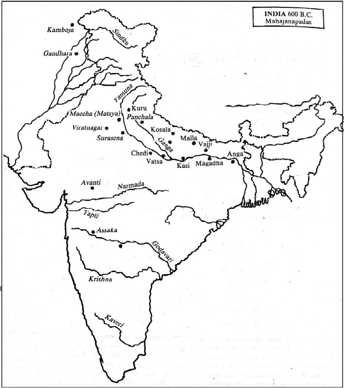
16 Mahajanapadas
Geographically, they stretched from Gandhara (NW Afghanistan-Pakistan) to Anga (E Bihar-Bengal) and from the foothills of the Himalayas to the Godavari River in the Deccan.
Anga
- The ancient kingdom of Anga was located in what is now the Bhagalpur and Munger districts in eastern Bihar.
- It stood at the junction of the Ganga and Champa rivers, giving it strategic importance.
- Its capital, Champa, is believed to be present-day Champanagara or Champapura, near Bhagalpur.
- During the 6th century BCE, Champa was regarded as one of the most prominent cities.
- It served as a thriving commercial hub, positioned along important trade routes of the time.
- Archaeological excavations at the site have uncovered fortified structures, including a moat surrounding the city.
- Ancient travel records mention that merchants from Champa sailed to Suvarnabhumi, likely referring to regions in Southeast Asia.
Magadha
- Magadha rose to prominence as the leading political power by the 4th century BCE.
- The kingdom was located in areas that now form Patna and Gaya districts of Bihar.
- It was naturally protected by key geographical features: Ganga River to the north, Son River to the west, Champa River to the east & Vindhya Hills to the south
- The initial capital was Girivraja (Rajagriha), identified with present-day Rajgir.
- Rajagriha was a significant religious center, associated with both the Buddha and Mahavira.
- Eventually, the capital shifted to Pataliputra, which aligns with modern Patna.
- Archaeological findings at Rajagriha include stone fortification walls, likely constructed during the reigns of Bimbisara and Ajatashatru in the 6th–5th centuries BCE.
Vajji/Vrijji Confederacy
- The Vrijji Ganasangha was situated in eastern India, to the north of the Ganga River.
- Its capital was Vaishali, believed to be located near Basadh in the Muzaffarpur region of Bihar.
- The Vrijji confederacy was regarded as one of the most significant Mahajanapadas during the time of the Buddha.
- The Magadhan king Bimbisara established marital alliances with the Vrijji Ganasangha, indicating close political ties.
- Historians generally consider the Vrijji/Vajji union to be a confederation of eight or nine clans, each maintaining autonomy and equal status.
- These clans preserved their individual identities while participating in a collective political structure.
- Although Buddhist and Jain texts refer to the Vrijjis as Kshatriya clans, this does not imply strict adherence to the varna system.
- The Vrijjis adhered more closely to clan-based traditions compared to contemporary kingdoms.
- Governance was conducted through an assembly system, typically comprising the heads of clans or families, reflecting their republican structure.
Mallas
- The Mallas occupied a region to the west of the Vajji confederacy.
- They functioned as a confederation of nine clans, similar in structure to other ganasanghas.
- Their political domain had two prominent centres:
–Kusinara, identified with present-day Kasia, located approximately 77 km east of Gorakhpur.
–Pava, which some scholars associate with Pawapuri in Bihar, while others link it to Padaraona village, about 26 km northeast of Kasia.
- The Mallas maintained a close alliance with the Vajjis, reflecting shared political and cultural ties.
- Despite this alliance, there were intermittent conflicts between the two confederacies
Kashi
- The kingdom of Kashi was among the earliest Mahajanapadas to rise to political prominence.
- It was geographically situated between the Varuna River (to the north) and the Asi River (to the south).
- Its capital city, Varanasi, located on the banks of the Ganga, derived its name from these two rivers.
- The Jataka literature frequently highlights the prolonged rivalry between Kashi and Kosala.
- This rivalry culminated during the reign of King Prasenajit (Pasenadi) of Kosala, who eventually absorbed Kashi into his kingdom.
- In contemporary geography, Kashi corresponds to the region surrounding modern-day Varanasi (Benaras) in Uttar Pradesh.
Kosala
- The kingdom of Kosala emerged as one of the most influential Mahajanapadas of its time.
- Its territorial boundaries were well-defined:
- East: Sadanira River (modern Gandak)
- West: Gomati River
- South: Sarpika or Syandika River (modern Sai)
- North: The foothills of the Nepal Himalayas
- Kosala had two major capitals:
- Shravasti in the north, identified with the present-day twin villages of Sahet-Mahet
- Kushavati in the south
- Mahet served as a key urban centre, while Sahet is associated with the ancient Jetavana Monastery, which was donated by the merchant Anathapindika to the Buddhist sangha.
- Other important cities within the kingdom included Saket and Ayodhya.
- King Pasenadi (Prasenajit), a renowned ruler and contemporary of the Buddha, played a crucial role in shaping Kosala’s political stature.
- Present-day Kosala roughly corresponds to parts of Lucknow, Gonda, Faizabad, and Bahraich districts in Uttar Pradesh.
Vatsa
- Vatsa, also known as Vamsa, was renowned for its fine cotton textiles.
- Its capital was Kaushambi, located near modern-day Prayagraj (Allahabad).
- Kaushambi was a major trade centre, strategically positioned on routes linking the Deccan, Ganga Valley, and North-West India.
- Excavations at Kaushambi have uncovered massive fortifications dating back to circa 600 BCE.
- Under the rule of King Udayana, Vatsa emerged as a powerful mahajanapada.
- King Udayana was a contemporary and rival of King Pradyota of Avanti, and their conflict is referenced in many legends.
- Udayana later became the central figure in three classical Sanskrit plays:
- Svapna-Vasavadatta by Bhasa
- Ratnavali and Priyadarshika by Harsha
Kuru
- The Kurus were based in the Ganga–Yamuna Doab region.
- As per Buddhist tradition, their rulers belonged to the Yuddhitthila gotra, tracing lineage from Yudhishthira.
- The capital was initially at Hastinapura, but due to a devastating flood, it was shifted to Kaushambi.
- The Jaina text Uttaradhyayana Sutra mentions a Kuru king named Isukara, ruling from the town of Isukara.
- During the time of the Buddha, the Kurus followed a monarchical form of governance, which later transitioned into a ganasangha (republican oligarchy).
- The Kurus maintained marital alliances with prominent dynasties like:
- Yadavas
- Bhojas
- Panchalas
Panchala
- The Panchala kingdom was located in the region corresponding to present-day Rohilkhand in Uttar Pradesh.
- It was geographically divided by the river Ganga into:
- Uttara (Northern) Panchala, with its capital at Ahichchhatra (modern Ramnagar, Bareilly district).
- Dakshina (Southern) Panchala, with its capital at Kampilya (modern Kampil, Farukkhabad district).
- According to Kautilya’s Arthashastra, Panchala initially functioned as a monarchical state.
- Later, it transitioned into a non-monarchical polity, likely a republic or oligarchy.
- Prominent urban centres within the mahajanapada included Kanyakubja (modern-day Kanauj), which held significant political and cultural importance.
Matsya
- The Matsya kingdom was located in the eastern part of present-day Rajasthan, encompassing regions around Jaipur, Alwar, and Bharatpur.
- Its capital was Viratnagara (modern Vairat), named after its legendary founder, King Virata.
- Buddhist sources often associate the Matsyas with the neighboring Surasena kingdom, suggesting political or cultural ties between the two.
Surasena
- The Surasenas were based in the Yamuna Doab region.
- Their capital was Mathura, a significant political and commercial centre in ancient India.
- According to Buddhist tradition, King Avantiputra of Surasena was a disciple of the Buddha.
- His name, meaning “son of Avanti,” indicates a likely matrimonial alliance with the Avanti kingdom.
- Mathura served as a key trade crossroads, linking:
- The northern plains to the Deccan
- And to the western coastal regions
Gandhara
- The Gandhara kingdom was located in the northwestern region of the subcontinent, covering present-day Peshawar and Rawalpindi districts in Pakistan.
- Its capital, Takshasila (Taxila), was a prominent hub of trade and learning in ancient India.
- Archaeological excavations at Taxila have identified three major urban sites:
- Bhir Mound – the oldest and earliest settlement, where silver punch-marked coins and other early coinage types have been discovered.
- Sirkap and Sirsukh – later planned cities reflecting urban evolution.
- Around the 6th century BCE, Gandhara was ruled by King Pukkusati (Pushkarasarin):
- He achieved a military victory over Avanti.
- Maintained diplomatic ties with Magadha, indicating Gandhara’s active role in interstate politics.
Kamboja
- The Kamboja kingdom was closely linked to Gandhara and occupied parts of the Hazara district, including present-day Rajaori region in Pakistan.
- Initially governed by a monarchical system up to the 6th century BCE.
- As mentioned in the Arthashastra, Kamboja later transitioned into a ganasangha (republican/oligarchic form of government).
Avanti
- Located in the Malwa region of central India (modern-day Madhya Pradesh).
- Had two capitals:
- Ujjayini (near present-day Ujjain)
- Mahishmati (identified with modern Mandhata in western Madhya Pradesh)
- Both cities served as key trade centres, connecting:
- North India with the Deccan
- Interior regions with the western coastal ports
- Gained prominence under the rule of King Pradyota, known for:
- Engaging in military confrontations with Vatsa, Magadha, and Kosala.
Chedi
- Located in the eastern part of Bundelkhand, in central India.
- Capital: Suktimati, identified with Sotthivatinagara (near modern Jabalpur, Madhya Pradesh).
- Other likely urban centres in the region include:
- Tripuri in the Narmada valley (near Jabalpur)
- Airakina (modern Eran) near Sagar
- Mentioned in ancient texts like the Mahabharata, confirming its historical significance.
Assaka (Asmaka)
- Situated in the Godavari valley in present-day Maharashtra.
- Capital: Potana/Podana, identified with modern Bodhan (near Nanded).
- Referenced in several ancient texts:
- Panini’s Ashtadhyayi
- Markandeya Purana
- Brihatsamhita
- Buddhist literature places Assaka along the banks of the Godavari river.
- According to the Jataka tales:
| State | Capital | Features |
| Anga | Champa | Trade center; connected to SE Asia (Suvarnabhumi). |
| Kashi | Varanasi | Later annexed by Kosala. |
| Kosala | Shravasti / Kushavati | Included Ayodhya, Shakyas; King Prasenjit. |
| Vajji | Vaishali | Confederacy; Mahavira’s maternal family; defeated by Magadha. |
| Malla | Kushinara / Pava | Buddha’s last meal and Mahaparinirvana sites. |
| Chedi | Shuktimati | King Shishupala; ally of Jarasandha; killed by Krishna. |
| Vatsa | Kaushambi | King Udayana; known for cotton textiles; linked to Avanti. |
| Kuru | Indraprastha | Known from Mahabharata; Kaurava-Pandava conflict. |
| Panchala | Ahichchhatra / Kampilya | Included Kannauj; divided by Ganga. |
| Matsya | Viratanagara | King Virata; mentioned in Mahabharata. |
| Shurasena | Mathura | King Avantipura; Buddhist influence. |
| Avanti | Ujjain / Mahishmati | King Pradyota; rival of Vatsa; major Malwa power. |
| Gandhara | Takshashila | Trade, learning center; later ruled by Persia. |
| Kamboja | Pooncha | Known for horses and cavalry; NW frontier. |
| Assaka | Potali (Telangana) | Only southern Mahajanapada; in Dakshinapatha. |
| Magadha | Rajagriha | Powerful state; ruled by Haryanka dynasty. |
SOCIO-ECONOMIC CONDITIONS DURING THE AGE OF MAHAJANAPADAS
Archaeological Phase and Urbanization
The 6th century BCE marked the beginning of the Northern Black Polished Ware (NBPW) phase and the second urbanization in India. NBPW pottery was glossy, fine, and elite tableware, though not always black or polished. It was found in northern India and even as far as Amravati in the south. This period also saw the emergence of punch-marked coins, burnt bricks, and ring wells, indicating material and economic progress.
Urban Settlements and Town Hierarchy
Between 600–300 BCE, there was a significant rise in villages and towns in the Ganga Valley. Urban centers were classified as Pura/Nagara (fortified city), Nigama (market town), Rajdhani (capital), Nagarka (small town), and Mahanagara (large city). Important cities included Kashi, Kaushambi, Rajgriha, Pataliputra, Shravasti, Ayodhya, Vaishali, Champa, and Kapilavastu. These were not just political centers but also major trade hubs with organized artisan and merchant guilds. Setthis were wealthy businessmen involved in trade and finance.
Crafts and Trade
Artisans lived in special merchant streets called vessas and mostly practiced hereditary professions. Goods like textiles, ivory items, and pottery were exported to distant regions. All major towns were connected by rivers and trade routes, with Uttarapatha and Dakshinapatha being the two main trans-regional routes. Trade linked India with Myanmar, Afghanistan, Iran, and Mesopotamia. Imports included gold, jade, silver, and lapis lazuli, while exports consisted of craft goods, pearls, and sandalwood.
Money and Administration
Trade was facilitated by metallic currency like Nishka and Satamana. Punch-marked silver coins were common, and wages were paid in money, as noted in Pali texts and Panini’s Ashtadhyayi. Custom officials (Kammikas) and toll officers (Shaulkika) collected taxes on goods. Rajabhatas ensured safety on trade routes.
Village Life and Rural Economy
There were three types of villages:
- Typical villages with caste-based communities under a village headman (gramabhojaka or gramini) who collected taxes and maintained law.
- Suburban craft villages such as carpenters’ (vaddhaki-grama) or saltmakers’ (lonakara-grama) villages, linking towns with rural areas.
- Border villages (aramika-grama) on forest fringes, inhabited by hunters and gatherers.
Land and Agriculture
Village lands were family-wise allotted, cultivated either by the family or with hired labour (dasa-kammakara). Rich peasants were called Gahapati. One-sixth of produce was paid as tax, collected by royal officials. No intermediaries existed between farmers and state, except in brahmadeya grants (land revenue given to Brahmins or merchants). These grants did not include administrative control.
Agricultural Advances
Use of iron ploughshares and fertile alluvial soil led to expansion in agriculture. This supported the growth of a food-surplus economy. Rice was the staple crop, with paddy transplantation common. Other crops included barley, pulses, millets, cotton, and sugarcane. The site of Atranjikhera (Etah, UP) offers valuable insights into the rural-urban transition of this period.
Key Battles and Their Influence
Bimbisara’s conquest of Anga circa 540 BCE proved transformative, largely due to its access to trade routes along the Ganga River and the strategic port of Champa. To resolve a conflict with Kosala over Kashi, marriage alliances were cleverly used, which only made Magadha stronger. Eventually, from 484 to 468 BCE, Magadha expanded its territory through siege warfare against the Licchavis, effectively removing its last major rival.
Around 400 BCE, the Shishunaga dynasty took control of Avanti, which was crucial for securing Magadha’s western trade routes. This, combined with the weakened Mahajanapadas due to Alexander’s conquests, created a perfect opportunity for Chandragupta Maurya to step in and establish India’s first empire. These events marked a shift towards centralised power, boosted trade and urbanisation in the Gangetic region, and paved the way for the growth of Buddhism and Jainism under Magadha, shaping the early historical landscape of India.
Subscribe to our Youtube Channel for more Valuable Content – TheStudyias
Download the App to Subscribe to our Courses – Thestudyias
The Source’s Authority and Ownership of the Article is Claimed By THE STUDY IAS BY MANIKANT SINGH