Font size:
Print
India’s Coastline Now Measures 11,099 km
Maths of India’s coastline lengthened without gaining land
Context: In December 2024, the Ministry of Home Affairs announced a significant revision to a long-standing geographical fact: India’s coastline length has officially increased from 7,516.6 km to 11,098.8 km.
More on News
- This update, detailed in the ministry’s 2023-24 annual report, marks a major shift in how we measure the nation’s coastal boundary—and it’s not due to any new territory or tectonic activity.
- The answer lies in improved mapping technologies and a fascinating mathematical phenomenon called the coastline paradox.
Why Did India’s Coastline Length Increase?
-
- Contrary to common assumptions, the revised coastline length does not reflect new islands, land annexation, or geological events.
- Goa was the last coastal state to join India in 1961, and since then, no coastal region has been added.
- The updated length stems purely from advanced measurement techniques and better mapping accuracy.
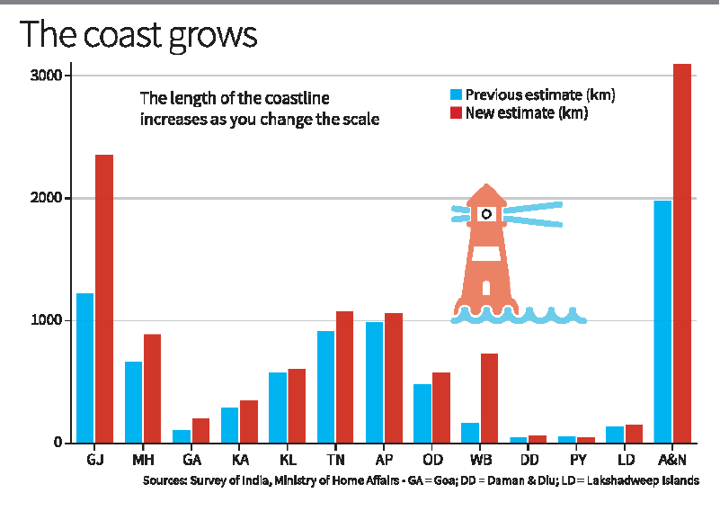
- Then vs Now:
-
- Old Method (1970s): Used low-resolution maps at 1:4,500,000 scale, ignoring fine features like tidal creeks, estuaries, and sandbars.
- New Method (2024): Uses high-precision electronic navigation charts at 1:250,000 scale, capturing intricate coastal details.
- The latest coastline measurement was carried out by the Survey of India and the National Hydrographic Office (NHO).
- They relied on highwater line data, satellite altimetry, LIDAR-GPS mapping, and drone-based imaging.
- Importantly, features like river mouths, tidal flats, and exposed island areas during low tide were also included.
Coastline Paradox: How Measurement Scale Changes Everything
The dramatic change in India’s coastline length isn’t just about better tools—it’s a direct consequence of the coastline paradox, a concept rooted in fractal geometry.
What is the coastline paradox?
-
- First noted by Lewis Fry Richardson and mathematically formalised by Benoît Mandelbrot in 1967, the coastline paradox reveals that the measured length of a coastline depends on the scale of measurement.
- The smaller the measuring unit, the longer the coastline becomes.
- For example: Using a 200 km ruler skips over many inlets and curves, giving a shorter total.
- A 50 km ruler captures more detail, increasing the length.
- At 1 km or less, every estuary, tidal creek, and indentation is measured, dramatically extending the total distance.
- Coastlines behave like fractals—not perfect fractals, but shapes that grow more complex as you zoom in.
- Thus, with each refinement in scale, the coastline “grows” longer, not because the land changed, but because we can now see it better.
Why This Matters: Maritime Security, Climate, and Economic Zones
- The 11,099-km coastline figure isn’t just a cartographic update—it has real-world implications:
- National Security: India now has more coastline to monitor and protect, especially amid growing maritime challenges in the Indian Ocean Region (IOR). This affects: Coastal surveillance, Naval and Coast Guard patrol planning and Border infrastructure.
- Disaster Preparedness: India’s extended coastline includes regions prone to cyclones, tsunamis, and sea-level rise. A more accurate length helps improve: Disaster risk models, Evacuation planning and Early warning systems.
- Marine Economy: A longer coast can extend India’s Exclusive Economic Zone (EEZ), directly impacting: Fisheries and aquaculture rights, Offshore energy exploration and Coastal tourism planning.
- Geographic Education and Mapping: School and college geography textbooks will require updates, as the previously taught 7,516.6 km figure is now outdated.
- It also sets a new precedent for how digital cartography and geospatial science redefine national boundaries.
What Comes Next?
- The government has announced that from 2024–25 onward, the coastline will be reassessed every 10 years to keep up with evolving technologies and environmental changes.
- While India’s coastline hasn’t physically changed, our ability to observe and measure it certainly has.
- The revised length of 11,098.8 km is not just a number—it’s a reflection of how scientific progress and fractal mathematics intersect to deepen our understanding of geography.
India’s updated coastline measurement is a reminder that science is not static. What was once measured with paper maps is now captured using satellite imaging and laser altimetry. The coastline paradox teaches us that geography is scale-sensitive, and as our tools sharpen, so does our picture of the world.