Font size:
Print
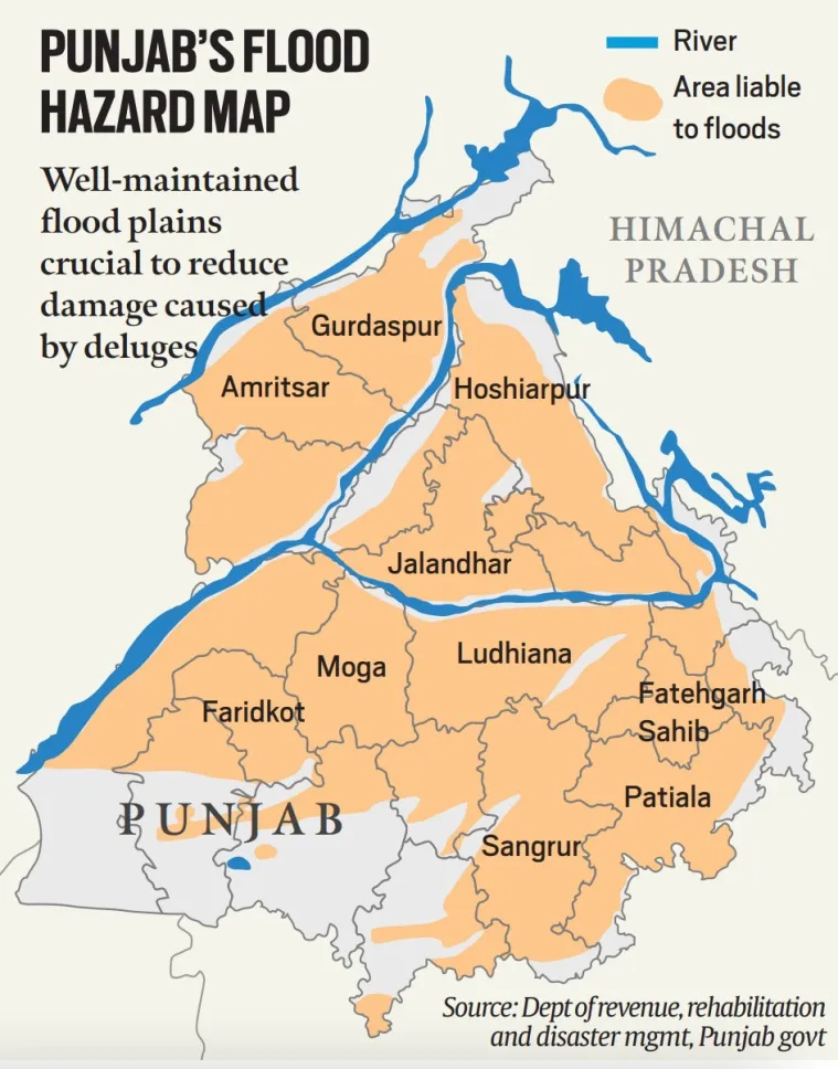
Floods in Punjab
Context: The devastating floods of August 2025—submerging over 1,400 villages and affecting all 23 districts—have exposed deep vulnerabilities in Punjab’s geography, infrastructure, and governance.
What are the major causes of floods?
Floods typically result from a combination of natural and human-induced factors. The key causes include:
- Natural drivers include intense monsoon rainfall, river overflow due to siltation, cloudbursts and cyclones causing flash floods, and snowmelt or landslides in the Himalayan regions.
- Human factors such as encroachment on floodplains, poor drainage infrastructure, unregulated dam releases, and illegal mining that weakens embankments further exacerbate flood risks.
Why do floods occur in Punjab?
Punjab’s flood vulnerability is shaped by its riverine geography and infrastructure gaps:
- River Network & Geography: Punjab is crisscrossed by five major rivers—Sutlej, Beas, Ravi, Chenab, and Jhelum—which swell during monsoons. The Doab region, between Beas and Sutlej, is especially flood-prone due to low elevation and high water table.
- Extreme Monsoon Events: In 2025, intense rainfall in Himachal Pradesh and Jammu & Kashmir triggered downstream flooding in Punjab. Sudden cloudbursts and erratic monsoon patterns—amplified by climate change—have made floods more frequent and severe.
- Infrastructure Failures: Poorly timed water releases from Bhakra, Pong, and Ranjit Sagar dams worsened the crisis. Neglected embankments, clogged canals, and blocked natural drains led to water stagnation and overflow.
- Human-Induced Vulnerabilities: Encroachment on floodplains and unregulated urban expansion reduced natural absorption zones. Illegal sand mining and deforestation weakened riverbanks and increased runoff. Poor zoning laws allowed construction in high-risk areas, amplifying damage.
What measures need to be taken?
- Planning & Governance: Enforce floodplain zoning regulations and halt construction in vulnerable areas. Create risk-based water governance protocols for dam operations and reservoir levels.
- Infrastructure Upgrades: Strengthen and maintain embankments and stormwater drains. Implement desilting programs for canals and rivers before the monsoon season.
- Environmental Restoration: Ban illegal sand mining and promote afforestation to improve soil absorption. Restore natural drainage channels and seasonal rivulets.
- Early Warning & Response Expand real-time flood monitoring systems and predictive modelling. Train local authorities and communities in disaster preparedness and evacuation protocols.
- Community Engagement: Involve panchayats and local bodies in flood risk mapping and mitigation. Launch awareness campaigns on flood-safe construction and land use.