Font size:
Print
Demand for Indo-Bhutan River Commission
Context: West Bengal Chief Minister Mamata Banerjee has once again called for the establishment of an Indo-Bhutan River Commission with West Bengal as a formal member.
What are the transboundary river issues between India and Bhutan?
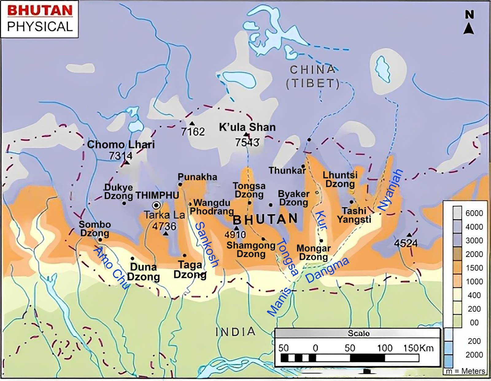
- Flooding and Erosion: Rivers originating in Bhutan, such as the Sankosh, Torsa, Jaldhaka, and Raidak, flow down into India. During the monsoon season, heavy rainfall in the Bhutanese hills causes these rivers to swell, leading to severe flooding and riverbank erosion in the downstream Indian districts of Alipurduar, Jalpaiguri, and Cooch Behar in West Bengal.
- Data Sharing and Early Warning: Delay or lack of coordination in data exchange on rainfall, water levels, and potential dam water releases minimises the crucial window for evacuation and preparedness in the flood-prone areas of North Bengal.
- Asymmetry in Development Projects: While large hydroelectric projects on these rivers in Bhutan (e.g., Punatsangchhu-I & II) are built with Indian cooperation and primarily benefit India’s energy needs, the downstream impact of such projects, including altered flow patterns and potential flash floods from sudden water releases, is a concern for the state of West Bengal.
- Tripartite Issue: The current bilateral mechanisms often sideline the state government, which is the primary entity dealing with the on-ground consequences of flooding.
What are the institutional mechanisms currently used for their resolution?
- Indo-Bhutan Treaty of Friendship and Cooperation (2007): This treaty provides the overarching framework for bilateral cooperation, including on water resources.
- Joint Group of Experts (JGE) on Flood Management: This is a high-level group with representatives from both governments that meets periodically to discuss and review flood management issues of common concern, including data sharing and early warning systems.
- Joint Technical Team (JTT): This team deals with the technical aspects of flood management, such as the implementation of specific measures and technical studies.
- Joint Team of Experts on Flood Forecasting and Data Sharing: This team focuses specifically on the operational aspects of sharing hydrological data to improve the accuracy and lead time of flood forecasts for downstream areas.
- Protocol on Hydrological Data Exchange: A specific protocol exists for the exchange of real-time data from hydrological stations in Bhutan to the Indian Central Water Commission (CWC).
What are the shortcomings of the present methods?
- Exclusion of Stakeholders: Only central agencies (MoJS, CWC) involved; West Bengal, the worst affected by floods (Jalpaiguri, Cooch Behar), is excluded, leaving a gap between decisions and ground realities.
- Fragmented Structure: Multiple bodies (JGE, JTT, Forecasting Team) with overlapping roles resulting in slow, uncoordinated flood management in the absence of any single umbrella authority.
- Limited Scope: Focus on data sharing & forecasting only, ignoring basin-wide management, erosion, hydropower-water sharing, and climate adaptation.
- Reactive Approach: Crisis-driven mechanisms without joint planning for reservoirs, embankments, or long-term river basin development.
- Weak Accountability: Protocols lack enforceable dispute resolution; downstream communities feel excluded, fueling grievances and politicisation.
What measures need to be adopted further?
- Formal Inclusion of State Representation: The most direct measure is the formal inclusion of West Bengal as a member in a reconstituted Indo-Bhutan River Commission or, at the very least, granting it permanent observer status in the existing Joint Group of Experts (JGE).
- Strengthening Paradiplomacy: While foreign policy remains the Union’s prerogative, “paradiplomacy” (sub-national diplomacy) can be effectively leveraged.
- Establishing a West Bengal-Bhutan Dialogue Forum: A formal, state-level mechanism, including Technical experts and bureaucrats for dialogue between the Government of West Bengal and the relevant Bhutanese ministries, can be created to discuss operational issues like local flood preparedness, erosion management, and community-level impacts.
-
Enhanced Technical Infrastructure:
-
- Advanced Early Warning Systems: Upgrading the technological infrastructure and developing integrated flood forecasting models that specifically cover the Bhutan-Bengal basin.
- Community-Based Disaster Preparedness: Jointly developing and funding community-based programs in the border districts of both Bhutan and India to enhance local resilience and response capabilities.
- Holistic Basin Management: Moving beyond just flood management to embrace Integrated Water Resource Management (IWRM) for the entire river basin.